 :
:Location and Climate
2019 Jan-31
Geography
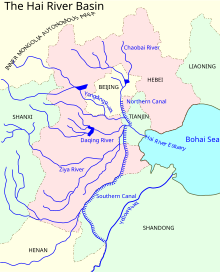
Tianjin is located along the west coast of the Bohai Gulf, looking out to the provinces Shandong and Liaoning across those waters, bordered by Beijing 120 kilometres (75 mi) to the northwest, and except for the east, is surrounded on all sides by Hebei. With a latitude ranging from 38° 34' to 40° 15' N, and longitude ranging from 116° 43' to 118° 04' E, the total area is 11,860.63 square kilometres (4,579.41 square miles). There is 153 km (95 mi) of coastline and 1,137.48 kilometres (706.80 miles) of land border. It lies at the northern end of the Grand Canal of China, which connects with the Yellow River and Yangtze River. The municipality is generally flat, and swampy near the coast, but hilly in the far north, where the Yan Mountains intrude into northern Tianjin. The highest point in the municipality is Jiuding Peak (九顶山) in Ji County on the northern border with Hebei, at an altitude of 1,078.5 m (3,538 ft).
The Hai River forms within Tianjin Municipality at the confluence of the Ziya River (子牙河), Daqing River (大清河), Yongding River, North Grand Canal, and South Grand Canal, and enters the Pacific Ocean within the municipality as well, in Tanggu District. Major reservoirs include the Beidagang Reservoir in the extreme south (in Dagang District) and the Yuqiao Reservoir in the extreme north in Ji County.
Climate
Tianjin features a four-season, monsoon-influenced climate, typical of East Asia (Köppen BSk bordering on Dwa), with cold, windy, very dry winters reflecting the influence of the vast Siberian anticyclone, and hot, humid summers, due to the monsoon. Spring in the city is dry and windy, occasionally seeing sandstorms blowing in from the Gobi Desert, capable of lasting for several days. The monthly 24-hour average temperature ranges from −3.4 °C (25.9 °F) in January to 26.8 °C (80.2 °F) in July, with an annual mean of 12.90 °C (55.2 °F). With monthly percent possible sunshine ranging from 48% in July to 61% in October, the city receives 2,522 hours of bright sunshine annually. Having a low annual total precipitation of 511 millimetres (20.1 in), and nearly three-fifths of it occurring in July and August alone, the city lies within the semi-arid zone, with parts of the municipality being humid continental.
Extreme temperatures have ranged from −22.9 °C (−9 °F) to 40.5 °C (105 °F).